
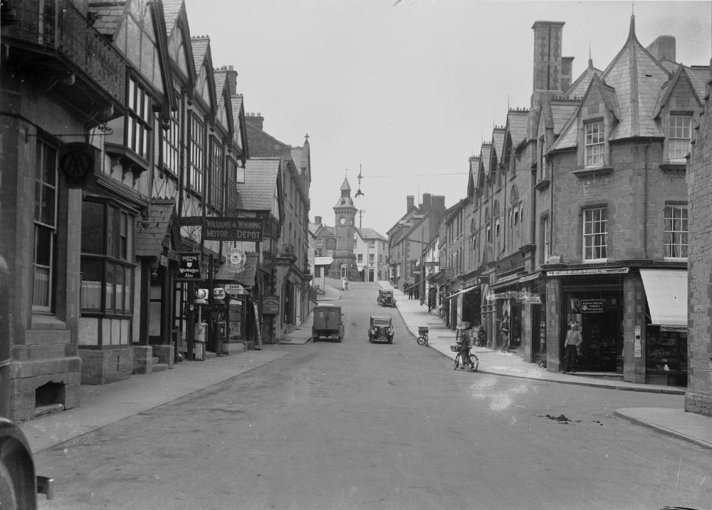
Knighton has always been a town of crossings. Its Welsh name, Tref-y-Clawdd, means the town on the dyke, and few places in Wales have been so closely shaped by their position between two countries. Offa’s Dyke passes through the town, the River Teme carries the landscape eastwards towards Shropshire, and even the railway station stands just across the national boundary in England while serving a town historically belonging to Radnorshire. Yet Knighton was never simply a settlement stranded on the edge of Wales. The border was one of the reasons for its existence and, for much of its history, one of the foundations of its prosperity.
Its story is quite different from those of the other principal Radnorshire towns. New Radnor grew beneath a medieval castle and later declined. Presteigne developed around law, county administration and the assizes. Rhayader served the upper Wye and the roads westwards into the mountains. Llandrindod Wells was largely a creation of the spa and railway age. Knighton developed as a trading town whose natural hinterland ignored the line between Wales and England. Farmers, wool merchants, drovers, craftsmen, carriers and later railwaymen all moved through a district in which the border was less a barrier than a meeting place.
Before Knighton
People had lived in the country around Knighton long before anything resembling the modern town appeared. Prehistoric hillforts and earthworks survive throughout the wider border landscape, while Roman activity was concentrated not far away around Leintwardine and the network of roads which crossed the Marches.
The most obvious survivor of the earlier landscape is Offa’s Dyke. Traditionally associated with Offa, king of Mercia between 757 and 796, the great earthwork remains one of the most remarkable monuments of early medieval Britain. Its precise date, purpose and extent have continued to attract debate, and it should not be imagined simply as a continuous military wall. Nevertheless, its presence at Knighton became fundamental to the town’s identity. Long after its original political purpose had disappeared, the Dyke supplied Knighton with its Welsh name.
Knighton itself appears in Domesday Book in 1086 as Chenistetone. The manor was then described as waste, almost certainly reflecting the disruption and warfare which accompanied Norman expansion into the border country. The English name probably originated in Old English and referred to a settlement associated with retainers or freemen. The later Welsh name therefore tells a rather different story, describing the town through the ancient earthwork beside which it developed.
That dual identity is important. Knighton has always been understandable in more than one way.
Castle, borough and market
The Norman conquest of the March transformed the district. Two castle sites survive at Knighton, although their precise chronology remains uncertain and it would be unwise to assign either confidently to a particular phase without stronger archaeological evidence. What is clear is that the town occupied an important strategic position and that William de Braose was associated with castle building at Knighton around the end of the twelfth century.
Below the castles a medieval settlement developed.
A market grant followed in the thirteenth century, and by the later 1200s Knighton had begun to assume the appearance of a planned borough. Roger Mortimer received a grant of murage in 1260, allowing money to be raised for defensive works, and another followed in 1277. These grants show how seriously Knighton’s defence was taken, although they do not necessarily prove that the town was ever completely enclosed by a conventional stone wall.
The surviving street pattern probably preserves something of this medieval expansion. Broad Street and the streets rising towards the castle appear very different in character, suggesting that Knighton developed in stages rather than according to a single plan.
One of the most revealing pieces of evidence comes not from buildings but from names.
A tax assessment of 1293 recorded seventy-one taxpayers in Knighton. Analysis of their names suggests that roughly two-thirds were Welsh. This is important because it complicates any picture of Knighton as simply an English colonial borough established against a Welsh countryside. The medieval population appears instead to have been strongly mixed, with Welsh inhabitants forming a substantial, possibly dominant, element.
The borough was also growing. In 1304, records associated with Edmund Mortimer listed 126 burgesses holding more than 162 burgages. For a small Marcher settlement this represented a significant urban community.
Knighton was therefore already becoming something more complicated than a fortified frontier post. It was a trading town populated by people from both sides of the cultural border.
Life on the medieval frontier remained insecure.
The town suffered during the wars between the Marcher lords and the princes of Gwynedd, and its defences must be understood against that background. The wider district again became dangerous during the revolt of Owain Glyndŵr at the beginning of the fifteenth century.
In 1402 the Battle of Bryn Glas was fought at nearby Pilleth, where Glyndŵr inflicted a serious defeat upon an English army led by Sir Edmund Mortimer. Knighton itself was subsequently caught up in the upheaval and appears to have suffered considerable damage.
The castle never recovered any lasting military significance.
Yet Knighton survived. The explanation lies not in fortification, but in commerce.
Sheep, wool and the making of the market town
The hills around Knighton provided the town with the economic foundation which would sustain it for centuries.
Sheep were central to the agricultural economy of the Radnorshire border country, and wool became one of the principal commodities passing through the town. Knighton collected produce from a wide rural hinterland and connected it with larger English markets. Cloth production and the wool trade provided opportunities for merchants and craftsmen, while farmers came into town for markets, fairs and supplies.
The relationship between Knighton and the surrounding countryside was therefore fundamental. The population living within the town itself gives only a partial indication of its importance. On market and fair days it served people who had travelled from farms and villages many miles away.
The wider story of these routes is explored in Hooves Across the Hills: The Drovers of Radnorshire. Cattle and sheep moving from Wales towards English markets passed through a network of roads, inns, stopping places and grazing grounds stretching across Radnorshire and the Marches. Knighton occupied an obvious position within that system. Its inns accommodated travellers, smiths attended animals and horses, traders exchanged information, and money moved through the town with the livestock.
The road was not merely a means of reaching Knighton. It was part of Knighton’s economy.
A borough between Wales and England
Knighton also possessed a civic identity which distinguished it from the surrounding countryside.
The borough had its own bailiff, burgesses and constables, while the town’s political history eventually connected it with the Radnor Boroughs parliamentary constituency. Knighton, New Radnor, Rhayader, Cefnllys and later Presteigne formed part of a peculiar system in which several small towns contributed towards the election of a single Member of Parliament.
The arrangement reflected the unusual geography of Radnorshire. There was no single overwhelmingly dominant town. Political influence was scattered among several small boroughs whose histories and economic interests differed considerably.
The most revealing evidence of Knighton’s civic life is sometimes found in apparently mundane legal documents.
A lease dating from 1729–30 concerned the standings, shops and other commercial rights attached to the Town Hall, together with the toll on corn brought to market. The annual rent was £26, but this was not the whole payment. The tenants were also required to provide a strike of the best wheat, a peck of white peas and two good fat pullets.
It is difficult to find a better glimpse of Georgian Knighton.
The Town Hall was not an abstract civic institution. It stood at the centre of buying, selling, food, rent, tolls and everyday exchange. Market administration and ordinary life were intertwined.
Later documents record innkeepers, bakers, shoemakers, masons, millers, saddlers and an apothecary among the burgesses. Knighton was a small town, but by the eighteenth century it possessed the occupational diversity expected of a place serving a much wider agricultural district.
Georgian Knighton
Knighton remained comparatively small for much of the early modern period. Population estimates suggest that growth before the nineteenth century was modest, and the town would still have been recognisably rural in character.
Markets and fairs set the rhythm of the year.
Agricultural prosperity brought money into the town, particularly during periods of high food prices, but poverty was never far away. Knighton established a workhouse towards the end of the eighteenth century, and surviving accounts show that poor relief was already an organised part of local life.
This is worth remembering when looking back at the Georgian market town. Prosperous farmers, merchants and innkeepers existed alongside labourers, widows, elderly people and families whose position could become precarious through illness, bad harvests or unemployment.
The town also developed a strong culture of entertainment.
Horse racing was being organised at Bailey Hill by at least 1784. Advertised meetings offered substantial purses and were accompanied by dinners and balls at local inns. Racing therefore belonged to the same world as the fairs and markets. It brought visitors into Knighton, provided business for public houses and created a temporary social gathering which drew together different levels of society.
Long before the railway, Knighton already understood the economic value of attracting a crowd.
Improved roads began gradually to loosen the geographical constraints which had shaped the town.
Turnpike routes and road improvements created easier connections with central Radnorshire, Herefordshire and Shropshire. Carriers moved goods and passengers more reliably, while coaching linked Knighton with larger commercial centres.
By the 1830s directories reveal a surprisingly varied town. Inns and public houses were numerous. Grocers, bakers, butchers, shoemakers, blacksmiths, carpenters and other trades served both local residents and people coming in from the surrounding countryside.
Knighton was still a country town, but it was no longer an isolated one.
The next generation would attempt something far more ambitious.
The Victorian remaking of Knighton
The middle decades of the nineteenth century transformed Knighton more thoroughly than any period since the Middle Ages.
Population rose from about 1,400 in 1841 to more than 1,850 twenty years later, before approaching 2,000 in 1871. Some of this growth reflected the temporary presence of railway workers and their families, but the broader trend was unmistakable.
Victorian Knighton was expanding.
This development did not happen accidentally. A relatively small group of businessmen, professionals, landowners, lawyers, clergy and merchants invested in institutions which they believed would make the town healthier, wealthier and more respectable.
Among them was Green Price, one of the most influential figures in nineteenth-century Knighton. He invested in banking, public buildings, railways and civic improvement. Isaac Devereaux Rutter, a wool stapler originally from Montgomeryshire, became another important figure. Rutter would serve as Knighton’s last borough bailiff and participated in both the Local Board of Health and the Burial Board.
Their generation attempted to remake the town.
A bank associated with Knighton, Kington and Radnorshire was established in the 1830s. A savings bank followed. Commercial investment grew alongside civic ambition.
Beginning around 1850, new public buildings were constructed through a company supported by local investors. They opened as a Farmers’ Club and Reading Room and also contained Assembly Rooms suitable for concerts, meetings, dinners and balls.
The combination is revealing.
Agriculture remained the foundation of Knighton, but the town’s leading inhabitants wanted something more than a livestock market. They wanted institutions associated with education, sociability and respectability.
The complex was eventually acquired by the Knighton Hotel Company and developed into the substantial hotel which became associated with the Norton Arms.
A farming town was acquiring the social architecture of Victorian civic confidence.
Some of Knighton’s greatest improvements were hidden beneath its streets.
Water supply and drainage had long been problematic. An official public-health inquiry in 1849 exposed unsatisfactory sanitary conditions, poor drainage and inadequate housing. A Local Board of Health was subsequently established in the 1850s.
Improvement was not straightforward.
Ratepayers argued about expense, commercial interests competed with sanitary requirements, and livestock markets themselves created problems in streets through which large numbers of animals regularly passed. Victorian reform therefore emerged through disagreement as much as through civic idealism.
Gas lighting visibly changed the town.
Following a public meeting in 1851, a local gas company was organised. Coal gas was chosen in preference to an alternative system advertised as Patent Vegetable Gas, and by late 1852 twenty-eight street lamps were illuminating Knighton. The number later increased.
For inhabitants accustomed to dark streets, the change must have been striking.
A modern town was being created not only through large public buildings but through drains, pipes, lamps and services which altered ordinary daily life.
The Silurian Woollen Mills
The opening of the Silurian Woollen Mills in 1854 represented one of the most ambitious attempts to industrialise Knighton.
William Banks established a substantial manufacturing enterprise powered by both water and steam. Instead of sending wool away for processing, supporters hoped that at least some of the value created by the surrounding sheep economy could remain within Knighton.
Contemporary enthusiasm was considerable.
There was a sense that industrialisation might offer a new future for a town traditionally dependent upon markets and agriculture.
The optimism was never completely fulfilled. Knighton did not become an industrial town in the manner of those farther east or in south Wales. Nevertheless, the mill became an important employer and a striking physical expression of the belief that the town could manufacture as well as trade.
Its later history would prove equally significant.
The railway arrives
The decisive change came with the railway, part of the wider transport transformation explored in The Mid-Wales Railway: The Lost Route Through the Heart of Wales.
Local supporters had campaigned enthusiastically for a line, and Green Price was among those closely associated with the scheme. The Knighton Railway Company received parliamentary authority during the 1850s, and Lady Jane Walsh ceremonially cut the first sod.
The first trains reached Knighton around the end of 1860, with regular passenger, goods and mail services beginning in 1861.
The railway altered the town’s relationship with distance.
Coal became cheaper. Building materials arrived more easily. Artificial fertilisers and other agricultural supplies could be brought into the district in quantities which had previously been impractical. Livestock could be sent rapidly to distant markets. Postal communication accelerated and passengers could reach Knighton with an ease which would have astonished earlier generations.
The effect upon agriculture was immediate.
Livestock traffic became sufficiently important that additional railway wagons were soon required during major sales and fairs.
The railway also assisted the physical improvement of the town itself. Pipes and other heavy materials required for water and sewerage schemes could now be transported directly to Knighton.
Yet railways always contained a contradiction.
They allowed Knighton producers to reach distant markets, but they also allowed cheaper manufactured goods from industrial centres to reach Knighton. Local craftsmen and businesses previously protected by distance suddenly faced far greater competition.
The railway connected Knighton to the modern economy while simultaneously exposing it to that economy.
There was also a geographical irony which remains today.
Knighton station was built across the River Teme in England.
A traveller leaving a Welsh market town could cross the river and board a train in Shropshire within minutes.
Few details better express Knighton’s border identity.
Racing beside the railway
Even the town’s entertainments adapted to the railway.
The old racecourse at Bailey Hill was inconvenient for the growing number of visitors who could now arrive by train. In 1862 a new course was therefore laid out on Green Price’s land beside the Teme, close to the station.
Its shape was unusual.
One landowner declined to permit part of the intended course to cross his property, forcing the organisers to create a figure-of-eight layout.
Local businessmen subscribed towards its construction, demonstrating once again how civic improvement, entertainment and commerce overlapped.
The railway had not merely changed how people worked. It changed how they enjoyed themselves.
Chapel against railway
Religion provides another revealing example of the disruption caused by Victorian modernisation.
Knighton’s Primitive Methodists initially met in a room above stables, an arrangement which became decidedly unpleasant during warmer weather. Following a religious revival during the winter of 1851–52, a proper chapel was built and opened in May 1852.
The associated tea meeting reportedly attracted between four hundred and five hundred people.
Yet the chapel had an extraordinarily brief existence.
Within less than a decade it appears to have stood in the way of the new railway and had to be demolished. A replacement building was begun around 1860.
It is difficult to imagine a more literal encounter between two forces transforming Victorian Knighton.
Religious revival built the chapel.
Industrial modernity knocked it down.
The Baptists had their own distinctive beginnings. In the 1830s a local woman who operated a school opened her cottage for Baptist worship. Meetings later transferred to the old Town Hall, baptisms were conducted in the River Teme, and a formal Baptist church was established in 1860.
Chapels and churches were not simply places of worship. They provided education, social networks, charity, music and community organisation.
During difficult winters later in the century, the churches and chapels helped distribute coal, clothing and other relief to poorer inhabitants.
Religion was part of the town’s social infrastructure.
St Edward’s and Victorian confidence
Knighton’s parish church was transformed during the same period.
The older church had been dedicated to St Lawrence. Much of it was reconstructed during the 1870s and subsequently dedicated to St Edward, with further work on the chancel following towards the end of the century.
The rebuilding belonged to the same world as the railway, gas lighting, banks, schools and public rooms.
Temporary services were held in the Assembly Rooms while the church was under reconstruction, illustrating how closely Knighton’s civic and religious institutions overlapped.
The present church is therefore another monument to the Victorian generation which reshaped the town.
The clock at the centre
Nothing symbolises Victorian Knighton more clearly than its clock tower.
The old market building had occupied the central area near the head of Broad Street. Once the site had been cleared, Thomas Moore of Old Hall offered to provide a clock tower for the town.
Designed in an elaborate Gothic style and completed during the 1870s, it created the landmark which still dominates central Knighton.
Moore died before seeing the finished structure.
The clock was more than decoration.
Contemporary accounts of the scheme looked back with pride upon the changes which had recently taken place, the railway, woollen manufacture, commercial companies, improved roads and public works.
The tower therefore became almost a monument to Knighton’s transformation.
There was also a practical symbolism.
The railway age demanded standardised time. Local clocks increasingly had to correspond with railway time rather than the older local measurement of the day.
Modernity was now displayed in hours and minutes above Broad Street.
A market capable of holding 6,000 sheep
For all the talk of industry and improvement, Knighton remained fundamentally dependent upon agriculture.
Perhaps the clearest evidence came surprisingly late in the nineteenth century.
In 1894 the sheep market behind the Norton Arms was rebuilt at a cost exceeding £2,000. Covering approximately two acres, it was capable of accommodating around 6,000 sheep.
That figure tells us more about Knighton’s economic importance than population totals alone ever could.
A town of fewer than 2,000 inhabitants possessed facilities capable of receiving several times that number of animals.
The explanation was its hinterland.
Farmers came from a wide surrounding district, bringing livestock into a town which remained one of the principal agricultural centres of the border country.
Thursday markets and a remarkable succession of annual fairs maintained traditions stretching back centuries.
Victorian Knighton had acquired railways, banks, hotels, gasworks, schools and public institutions, but sheep remained at the heart of its economy.
Flood
The River Teme which helped shape Knighton could also become destructive.
At the end of December 1880, heavy rain combined with rapidly melting snow to produce one of the largest floods remembered in the town.
At Mill Green, water entered houses and forced residents upstairs. In one particularly vivid incident, a household reportedly carried a pig upstairs with them rather than allow it to drown.
The railway was threatened and buildings near the river were inundated. The gasworks flooded badly enough to interrupt the supply, leaving parts of Knighton in darkness.
Such moments recover something easily lost in institutional history.
The Victorian town was being improved through engineering, drainage and modern services, yet its inhabitants still lived within a landscape capable of overwhelming those improvements in a matter of hours.
Poverty and the workhouse
Behind the civic optimism remained another Knighton.
The Poor Law Amendment Act led to the establishment of Knighton Poor Law Union in 1836. Its district crossed the boundaries of Radnorshire, Herefordshire and Shropshire, again demonstrating how little the practical geography of the region respected the national border.
A new workhouse was erected during the following year to house around 120 inmates.
Its architecture and routine embodied Victorian ideas about poverty. Relief was deliberately made institutional and disciplined, with the workhouse intended to distinguish between those considered genuinely incapable of supporting themselves and those believed capable of work.
The building later required substantial reconstruction.
In December 1907 it became the scene of tragedy.
A smell of escaping gas had been detected. The workhouse master, Richard Morgan Butler, investigated after the gas supply had been turned off. He entered carrying a candle.
An explosion followed.
Part of the administrative building was wrecked and Butler was found beneath fallen debris with terrible injuries. He died later that day. An inquest recorded accidental death and found no negligence.
The building subsequently experienced an extraordinary transformation.
During the First World War it served as a Red Cross hospital. Later it became a Public Assistance Institution, and following the creation of the National Health Service it developed into Knighton Hospital.
A building created to embody the Victorian poor law eventually became part of a universal public health service.
Few sites in the town demonstrate social change more clearly.
The First World War reached deeply into a town the size of Knighton.
Men left farms, shops, railway work, offices and workshops for military service. Those who did not return were later commemorated within the town.
Their names represent only the visible part of the disruption.
Behind them were widows, parents, children, employers and congregations who had known them personally. In a small community the distance between a name on a memorial and everyday life could be very short.
The Second World War brought another generation into contact with national events. Evacuees came into the district, and surviving evidence records special cinema screenings for local children and evacuees during the war years.
Knighton remained geographically remote from the principal centres of conflict, but it was never detached from them.
The twentieth-century history of Knighton did not simply become a story of agricultural decline.
One of its most interesting industrial enterprises grew from a small garage business.
S. W. Brisbane & Son began trading in Knighton shortly after the First World War. By the late 1930s it had begun remoulding tyres for local farmers. After the Second World War that side of the business expanded rapidly, eventually occupying the former woollen mill.
There is something particularly appropriate in this.
A building associated with the nineteenth-century wool economy found a new purpose in the age of the motor car.
During the 1960s the company developed radial-ply tyre retreading and expanded into a substantial manufacturing operation. By the early 1970s around one hundred people were employed, producing thousands of remoulded tyres each week.
Knighton-made products travelled throughout Britain and were exported overseas.
The town which had once moved wool and livestock towards distant markets was now sending manufactured tyres far beyond Wales.
The product had changed.
The function had not.
Knighton was still connecting the resources and labour of a small border town with a much larger economy.
The Heyope fire
That industry eventually produced one of the most dramatic environmental episodes in modern Knighton history.
In October 1989 a huge fire broke out in a scrap-tyre dump at Heyope, near the town.
Around ten million tyres were later said in Parliament to have been present at the old site. The blaze took many days to control and continued smouldering beneath the ground long afterwards.
Pollution entered the nearby Ffrwdwen brook and concern spread over the environmental consequences.
The cause was suspected to have been deliberate, although this was never established conclusively.
The episode illustrated a difficult contradiction.
The tyre industry provided important employment to Knighton, with around a hundred people still dependent upon it, yet the waste produced by that industry had created a serious environmental hazard.
Modern economic development had brought its own problems, just as Victorian industrialisation had done a century earlier.
From boundary to heritage
By the later twentieth century Knighton was once again adapting to changing circumstances.
Traditional agriculture remained important, but the number of people directly employed on the land declined. Retail patterns altered, manufacturing contracted and increasing numbers of residents travelled elsewhere for work.
At the same time, the landscape which had once defined Knighton as a frontier began to offer another economic possibility.
The Offa’s Dyke Association was founded at Knighton in 1969, with local schoolteacher and archaeologist Frank Noble closely involved. The Offa’s Dyke Path opened as a long-distance trail soon afterwards.
A modern visitor centre eventually followed.
There is an appealing historical symmetry in this.
An earthwork constructed more than a thousand years earlier as part of a political frontier had once helped define Knighton’s place on the edge of Mercia.
During the Middle Ages that frontier encouraged castle building and military defence.
Later the border became part of the town’s trading advantage.
By the twentieth century, Offa’s Dyke had become a heritage asset bringing walkers and visitors into Knighton.
The boundary which once divided had become something people travelled long distances to follow.
The town on the Dyke
Knighton is sometimes described simply as a border town.
That is correct, but it does not go far enough.
The border was never merely a line running beside the town. It shaped Knighton’s entire history.
It encouraged medieval fortification but also created commercial opportunity. It produced a borough whose medieval population appears to have been strikingly Welsh despite its location within the March. It allowed Knighton to collect wool, livestock and agricultural produce from the Welsh uplands while remaining closely connected with the markets and commercial networks of England.
The same pattern continued in different forms.
Drovers crossed the hills. Merchants bought wool. Innkeepers accommodated travellers. Georgian crowds gathered for races and fairs. Victorian businessmen built banks, schools, gasworks and public rooms. Railwaymen carried livestock and goods through the border. A sheep market capable of holding 6,000 animals served farmers scattered across a much larger countryside. Later an old woollen mill became part of a tyre industry exporting manufactured goods overseas.
Knighton repeatedly adapted without entirely abandoning what had come before.
That is perhaps the most distinctive feature of its history.
The medieval borough survives beneath the modern streets. The Victorian clock still dominates Broad Street. The railway remains across the river in England. The hills which once supplied wool and livestock still surround the town. Offa’s Dyke still passes through it.
New Radnor became a village after losing much of its medieval importance. Presteigne became associated with county government and law. Rhayader looked towards the upper Wye and the western mountains. Llandrindod Wells grew around visitors, mineral waters and the railway.
Knighton remained the town between worlds.
Its Welsh name captures the geography perfectly.
Tref-y-Clawdd, the town on the Dyke.
Its history, however, shows that the Dyke was never the end of anything.
For Knighton, it was usually where things met.
Related Essays
- The Town That Became a Village: The Rise and Decline of New Radnor
- Presteigne: The Making of Radnorshire’s Old County Town
- Rhayader: The Making of a Radnorshire Market Town
- Hooves Across the Hills: The Drovers of Radnorshire
- Newbridge-on-Wye: A Village Made by Movement
- The Mid-Wales Railway: The Lost Route Through the Heart of Wales
Explore more Radnorshire history
Continue with the Radnorshire History guide, or browse the related essays above.
Receive new historical essays by email
For new essays on Welsh history, biography, genealogy and rural community life, subscribe on the homepage.
Sources and Further Reading
The principal archaeological background to medieval Knighton is provided by the Clwyd-Powys Archaeological Trust, now Heneb, particularly its historic settlement studies of Knighton and its surveys of the castle sites and parish church. These are especially valuable for the medieval street pattern, the uncertain chronology of the two castles and the archaeological development of the borough.
Evidence for the medieval population, burgages and Welsh personal names can be found in academic research into the medieval towns of Radnorshire and the Welsh Marches. The murage grants of 1260 and 1277 provide additional evidence for attempts to defend the borough during the thirteenth century.
The Price of Norton papers held by the National Library of Wales contain unusually rich material relating to Knighton’s Town Hall, market stalls, standings, tolls and fairs. The lease of 1729–30, with its rent partly paid in wheat, peas and fat pullets, provides a particularly vivid picture of the Georgian market economy.
Keith Parker’s work on the history of Knighton remains an important modern study of the town. The Transactions of the Radnorshire Society also contain material useful for understanding Knighton within the broader economic and social history of the county.
Nineteenth-century directories and contemporary newspapers, particularly those covering Radnorshire, Herefordshire and Shropshire, provide extensive evidence for Knighton’s markets, fairs, woollen manufacture, railway, races, gas supply, public institutions and Victorian rebuilding.
Official public-health reports and Local Board records are important for understanding drainage, water supply and sanitary reform. The records of Knighton Urban District Council held by Powys Archives provide further evidence for later housing, public health, planning and twentieth-century development.
The history of Knighton Poor Law Union and the workhouse provides an important counterpoint to accounts of Victorian prosperity. Surviving records trace the building from poor-law institution through its wartime hospital use and eventual incorporation into the National Health Service.
Research into the Primitive Methodist and Baptist congregations helps reconstruct the religious and social life of Victorian Knighton, while the Church in Wales heritage record for St Edward’s provides the architectural history of the parish church.
The twentieth-century tyre industry is documented through contemporary motoring sources and parliamentary records. The House of Commons debate following the 1989 Heyope tyre fire provides particularly valuable evidence for the scale of the waste site, the environmental damage and the importance of tyre manufacture to local employment.
For the wider Radnorshire context, this history is best read alongside the essays on New Radnor, Presteigne, Rhayader, the drovers of Radnorshire and the broader history of the county.
Online reference material consulted includes Heneb’s historic settlement study of Knighton, the Price of Norton deeds at the National Library of Wales, the Radnorshire Society Transactions, research on Victorian Knighton available through the Open University research repository, the Church in Wales heritage record for St Edward’s, and the House of Commons debate on the Heyope tyre fire.
The feature image is P. B. Abery’s early twentieth-century photograph of Broad Street, Knighton, from the National Library of Wales collection. The image is released under CC0 / public domain and shows the historic centre of the town with its Victorian clock tower.