
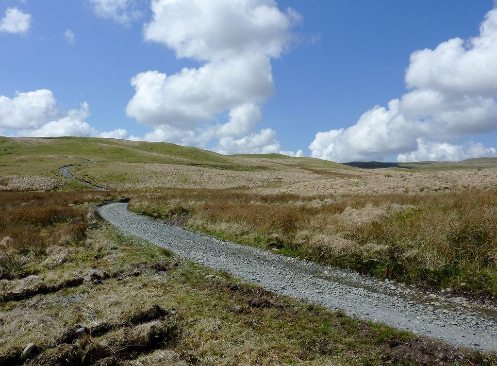
There are places in Wales where history survives because later generations found them useful, and others where it survives because the modern world largely passed them by. The Monks’ Trod belongs to both. For roughly twenty-five miles it crosses the Cambrian Mountains between the country around Strata Florida and the upper Wye valley, running through some of the most remote upland landscape in Wales before continuing towards Abbey Cwmhir in Radnorshire. In places it is a substantial terraced road. Elsewhere it narrows, fades into grass or disappears into peat and water. There are no walls or towers to announce its importance. The road itself is the monument.
I wrote about the Monks’ Trod for Nation.Cymru in June 2025 because the argument then surrounding its future seemed to expose a wider problem in the way we value the Welsh uplands. A rough track can look empty or neglected if judged only by modern standards. To a historian it may be anything but empty. Roads preserve movement, ownership, economy and memory. In the case of the Monks’ Trod, the surviving line across the hills opens a window onto the organisation of medieval Wales, the Cistercian economy, the power of the native princes and the long continuity of pastoral life in the Cambrian Mountains.
Modern archaeological work has confirmed that this was not simply a path worn into the ground by centuries of passing feet. Professor Andrew Fleming’s study of the route identified long sections built by cut-and-fill construction, where material was cut from the uphill side and used to create a terrace across the slope. In the central section he also identified additional width which may have allowed for the movement of livestock. The Royal Commission on the Ancient and Historical Monuments of Wales consequently describes the Monks’ Trod as a celebrated ancient road linking the Teifi basin with the upper Wye valley.
Since Fleming’s work, field archaeology has made that picture more tangible. During maintenance works in March 2018, Archaeology Wales carried out a watching brief along part of the route west of Rhayader. Archaeologists exposed surviving sections of paving and metalling, in places accompanied by stone edging or kerbing. The remains were not hypothetical traces inferred from topography, but actual constructed road fabric surviving beneath and beside the modern line. Where the road crossed firmer natural ground, particularly where bedrock already provided a reliable surface, little additional construction appears to have been necessary. Farther west, where conditions were less forgiving and suitable stone more readily available, paving and metalling occurred more frequently. The builders therefore seem to have improved the route selectively rather than laying a uniform road from end to end.
That distinction matters. Britain has many old paths. Far fewer retain substantial evidence of medieval or early historic road engineering over such a distance. In more populated parts of the country, useful medieval routes often became later highways, repeatedly widened, straightened and resurfaced until their earlier character was buried beneath centuries of improvement. The remoteness of the Cambrian Mountains saved much of the Monks’ Trod from that fate. Its very inconvenience, which can seem a problem today, is one of the reasons so much of its historical character survives.
The Cistercians and the upland economy
The familiar explanation is that the Monks’ Trod linked the Cistercian abbeys of Strata Florida and Abbey Cwmhir. That is broadly true, but it can give the misleading impression of monks simply walking from one monastery to another across the hills. The real story is larger, because a great medieval abbey was not merely a church surrounded by cloisters. It was the centre of an extensive landed economy.
The Cistercians established themselves at Strata Florida in 1164, first at Hen Fynachlog, before moving to the site of the later abbey under the patronage of Rhys ap Gruffudd, the Lord Rhys. By the closing decades of the twelfth century Strata Florida had become one of the most important religious houses in Wales. Abbey Cwmhir developed during the same broad period, and both belonged to a wider Cistercian network which included Whitland and Strata Marcella. Their estates were not confined to the land immediately around the monastery. They stretched into grazing grounds, granges, woodland, fisheries and upland pasture scattered across central Wales.
Strata Florida’s possessions extended deep into the Elenydd. Cwmteuddwr, west of the Wye, formed part of a huge monastic grange, while other holdings and routes connected the abbey with the interior. Such land had to be worked and supervised. Animals had to be moved between pastures, rents and produce collected, messages carried, officials sent out, and servants, lay brothers, tenants and herdsmen moved through country which was difficult but economically valuable. Medieval uplands which appear almost empty to us were working landscapes.
The landscape near Troed y Rhiw, east of Strata Florida, shows what that working world looked like on the ground. Detailed fieldwork by Andrew Fleming and Louise Barker identified four abandoned medieval farmsteads and a probable sheep-management complex in the western approaches to the route. One of the sites may have originated as a monastic bercaria, a specialised sheep establishment. Three of the farms appear to have lain along a ffridd boundary, separating more intensively managed lower pasture, and perhaps cultivated ground, from open mountain grazing above. The road therefore passed not through an empty wilderness but through an organised pastoral landscape whose divisions, farms and livestock installations can still be read archaeologically.
This landscape belonged to the great Pennardd estate associated with Strata Florida, a large upland territory stretching from the upper Teifi towards the upper Wye. Documentary and archaeological evidence also preserves the medieval pedigree of farms close to the road. Troed y Rhiw Issa, for example, appears in later records under an earlier name, Penddolfawr Ucha, and its form, naming and tenurial relationships point to origins in the medieval estate. The Monks’ Trod should therefore be imagined as threading together not just two monasteries but a web of farms, sheep walks, grange land and seasonal grazing.
The route through the Nannerth country reinforces the same point. The historic line did not always correspond precisely with the path followed today. Evidence near Nannerth Ganol, long associated with monastic landholding, suggests an older descent which included sharp bends unlike most of the surviving route. Nearby, the track crosses Nant y Sarn and passes through the Lluest Pen-rhiw field system, where it becomes braided in places. Such braiding is significant because it shows that an ancient route may have functioned as a corridor rather than as a single immutable line. Travellers and animals shifted sideways across the ground as erosion, bog, gradient and local usage changed.
The Monks’ Trod makes far more sense when seen as part of this system. Its line linked the Teifi country with the upper Wye and passed through or close to estates of direct importance to Strata Florida, including the country around Nannerth and Cwmteuddwr. Fleming’s reconstruction also identified a branch towards Strata Marcella near Welshpool. What looks today like an isolated track was therefore once part of a network joining monasteries, estates, grazing lands and communities across mid Wales. The road was infrastructure. That is perhaps the simplest way of understanding its medieval importance.
Building a road across the mountains
The engineering is important because it shows intention. Where the Monks’ Trod survives as a terraced road, considerable labour was required to create it. Builders selected a workable line, cut into slopes, moved soil and stone, dealt with gradients and, in some places, provided a constructed surface. This was more than the gradual creation of a footpath.
Fleming’s work demonstrated that the road was often designed to ease movement across difficult ground. Long stretches follow contours or cross slopes obliquely rather than simply attacking the steepest gradient. Where natural ground made passage straightforward, little or no construction was necessary. Where it did not, labour was invested in producing something more reliable. The additional width found in part of the central section is especially interesting because it suggests that livestock movement may have been considered when the road was laid out. A route serving an upland sheep economy did not need to function only as a narrow way for mounted travellers or pack animals.
The 2018 archaeological work adds another layer to this story. Alongside the surviving paved and metalled road, investigators identified a sunken hollow-way running broadly parallel to part of the present route. They suggested that it may represent an earlier alignment which had fallen out of use before traffic shifted onto slightly higher and more accessible ground nearby. If that interpretation is correct, the Trod preserves not one road but successive phases of movement across the same corridor. The road changed while its broader purpose endured.
The uneven survival of its stonework may also be historically significant. At the western end of the 2018 study area, only short sections of kerbing remained. Archaeology Wales suggested that stone-robbing in the post-medieval period may explain some of the loss, with road material possibly reused in nearby farm buildings and field boundaries. That possibility is entirely plausible in a landscape where dressed or conveniently gathered stone was valuable. Parts of a medieval road may therefore survive today not only beneath our feet, but incorporated into the later agricultural landscape around it.
There is an environmental dimension to the dating too. Fleming noted that in places the route appears to have been affected by later bog growth, potentially associated with climatic deterioration during the Little Ice Age. If so, ground which is exceptionally wet today may not have been in precisely the same condition when the route was laid out. The road should not automatically be judged by the difficulty of crossing the modern peat surface, because some of that peat may have developed or deepened after the road itself was already established.
That brings us close to the practical world of medieval Wales. A road of this kind required organisation. Someone had to decide that it was worth building, labour had to be assembled and the route had to serve a purpose important enough to justify the effort. The monasteries clearly had such a purpose, but they may not have been the only interested authority.
The Lord Rhys and the road through his Wales
Rhys ap Gruffudd, usually known as the Lord Rhys, was the dominant ruler of Deheubarth during the later twelfth century and one of the most capable Welsh princes of the Middle Ages. His patronage of Strata Florida was part of a much wider relationship between native Welsh lordship and the Cistercian order. The abbey became closely associated with the political and cultural world of the Welsh princes, and its growth took place within a landscape over which Rhys exercised considerable authority.
Fleming suggested that an engineered route across the Cambrian Mountains would have served the organisational needs of Rhys as well as those of the Cistercians. The point is persuasive, even if the precise circumstances in which individual stretches were built remain open to debate. Medieval government depended on movement. Lords required messengers, retainers and officials to cross their territories, estates needed supervision, and political authority was difficult to exercise where communication was impossible.
We naturally associate medieval power with castles because castles survive conspicuously. Roads are easier to overlook. Yet the ability to move through a territory was as important as the ability to defend it. If substantial parts of the Monks’ Trod belong to the age of the Lord Rhys, the road may preserve something unusually intimate, part of the practical infrastructure which allowed native Welsh power to function across difficult country.
There is, however, an important qualification. Fleming argued for major construction in the later twelfth century, but other work has reopened the question of dating. Following Edward I’s campaigns in Wales, orders were issued in the late thirteenth century for woods to be cleared and passes improved around monastic estates. In 1284 Strata Florida was instructed to enlarge passes, part of a wider Edwardian effort to make routes safer and more usable for royal forces and administration. Some archaeologists have therefore suggested that engineering attributed by Fleming to the twelfth century could include later thirteenth-century improvement.
The documentary record also requires caution. No surviving contemporary source states plainly that Rhys ap Gruffudd or the monks of Strata Florida built the Monks’ Trod as a single engineered highway. Gerald of Wales travelled between Strata Florida and Abbey Cwmhir during the journey through Wales in 1188, yet did not describe a special constructed road between them. John Leland, exploring the Strata Florida country shortly before the Dissolution, likewise left no description of the route. Neither silence disproves its existence, and old roads often escaped notice precisely because they were ordinary parts of the landscape, but the absence of contemporary testimony means that a precise twelfth-century attribution remains an archaeological interpretation rather than a documentary certainty.
That uncertainty should not be concealed, because it makes the road more interesting rather than less. The Monks’ Trod may not represent a single moment of construction. It may preserve several phases in the history of medieval Wales, an established upland route, Cistercian organisation under the native princes, later adaptation after the Edwardian conquest and still further change as pastoral and droving economies reshaped the road. Roads, like buildings, can have biographies.
How old is the Monks’ Trod?
The question of age is therefore more complicated than the familiar label suggests. Archaeological records have long raised the possibility that parts of the route followed a line which pre-dated the Cistercians, perhaps incorporating earlier tracks through a landscape already marked by prehistoric monuments and older communications. Suggestions of a relationship with Roman routes have also appeared in archaeological records, although the evidence is not strong enough to describe the Monks’ Trod itself as a Roman or prehistoric road.
The distinction is important. We do not need to make the Trod older than the evidence allows in order to recognise its significance. Medieval builders commonly used geography which had already proved practical. Mountain passes, river crossings and approaches through difficult upland country could retain their usefulness for centuries. It is entirely possible that the Cistercian and later medieval road formalised parts of an older line without that earlier route ever having possessed the same construction or purpose.
Place-names offer supporting clues, although they must be handled carefully. Nant y Sarn, crossed by the route, preserves a name associated with a road or causeway. Names of this kind can preserve memory of movement through a landscape, but they cannot by themselves prove a medieval date. Fleming therefore treated place-names as only one strand among several, to be considered alongside field relationships, constructional evidence and the way the road interacts with later features.
The history of the name “Monks’ Trod” is itself revealing. Late nineteenth-century Ordnance Survey mapping treated the line more cautiously as an “Ancient Road”, while the monastic name circulated in local and antiquarian tradition. The earliest clear written version of the picturesque “Monks’ Road” story appears to belong to nineteenth-century antiquarian writing. Jonathan Williams, in his history of Radnorshire, imagined monks passing periodically between the houses, even processing across the hills in devotional fashion, but he did not identify a medieval source for the tradition. The familiar image of cowled monks moving ceremonially over the mountains is therefore part of the route’s later cultural history and should not be confused with contemporary medieval testimony.
What matters is continuity. The Cambrian Mountains did not change when political systems changed around them. The same ridges, valleys, rivers and bogs continued to determine how people and animals could move. A route might therefore serve very different societies in succession while remaining recognisably the same way through the hills.
Strata Florida and the world at the western end
The importance of the road becomes clearer when we consider the places it connected. Strata Florida was not simply one abbey among many. It became one of the great institutions of medieval Wales, associated with the native princes, with burial, learning and the preservation of Welsh historical memory. Gerald of Wales and Archbishop Baldwin visited during their journey through Wales in 1188, and in 1238 Llywelyn ab Iorwerth used Strata Florida for the gathering at which Welsh rulers acknowledged his son Dafydd as his successor.
The abbey also stood at the centre of a large working estate. Monks, lay brothers, tenants, servants, messengers, visitors and herdsmen moved through the surrounding countryside. Pilgrims and political figures came to the monastery for entirely different reasons, while people whose names rarely reached the written record worked the land which sustained it. The road belongs as much to those unnamed people as it does to abbots and princes.
This is particularly important when looking at the uplands today. The apparent emptiness of the Elenydd can encourage the assumption that the country beyond the settled valleys was historically marginal. It was remote, but it was not useless. Pasture, water, fish, woodland and livestock all had economic value. Seasonal movement and dispersed settlement left a different archaeological signature from towns and villages, but the landscape was nevertheless occupied, managed and understood. The Monks’ Trod was one of the threads which bound that dispersed world together.
Abbey Cwmhir and the Radnorshire end
At the eastern end stood Abbey Cwmhir, another Cistercian house with strong connections to the political history of medieval Wales. Its surviving ruins reveal only a fraction of the ambition of the original church, which was planned on an extraordinary scale. Cwmhir later became associated with one of the defining moments in the destruction of independent Welsh rule when the body of Llywelyn ap Gruffudd was buried there following his death in December 1282.
The surviving route can be followed in broad terms from Abbey Cwmhir across Moel Hywel towards St Harmon, then across the Wye at Pont Marteg, climbing towards Pont ar Elan before turning south-west past the Claerwen country and the Teifi Pools and eventually descending through the Troed y Rhiw landscape towards Strata Florida. At Abbey Cwmhir itself, parts of the line survive as a zig-zagging descent of Cwm-hir Bank before the route crosses the Moel Hywel ridge. The geography makes clear just how ambitious the crossing was. It joined two very different river systems by threading a usable line through some of the most difficult ground in central Wales.
There is something particularly evocative about a road connecting these two houses. Strata Florida became one of the great cultural and political centres of native medieval Wales, while Cwmhir received the body of its last ruling prince. Between them lay a route crossing country which was itself part of the economic and political life of the period.
The road should not be romanticised into a ceremonial highway between national shrines. Its daily purpose was almost certainly more practical. Yet that practical purpose is precisely why it matters. Medieval Wales was held together not only by battles, dynasties and monasteries, but by people moving between places, carrying messages, managing land and driving animals. The Monks’ Trod preserves part of that ordinary machinery of history.
After the monasteries
The Dissolution of the Monasteries in the sixteenth century ended the religious institutions which had given the route much of its medieval importance, but it did not remove the geography which had made the road useful. The upland economy continued, farms remained, animals still had to be moved, and tracks through the mountains continued to connect communities with markets and neighbouring districts.
By the later seventeenth century the route enters the documentary record more securely. John Ogilby’s great road atlas, Britannia, published in 1675, shows a track meeting the Rhayader to Cwmystwyth road at Pont ar Elan and running towards “Rhose Ffaire”, modern Ffair Rhos. The line corresponds closely with the route later known as the Monks’ Trod. Because Ffair Rhos was associated with livestock fairs, the map provides strong evidence that the road had become part of the post-medieval pastoral and droving economy by this date.
That is an important distinction. The droving use of the Monks’ Trod does not need to be inferred merely from the general history of Welsh cattle roads. Here we have a seventeenth-century cartographic source placing the route within a network leading towards a fair. The road may have begun as part of a monastic and princely landscape, but by Ogilby’s day it was serving a different economy.
The wider Monks’ Trod became associated with the later droving landscape of Wales. Cattle and other livestock moved long distances on foot before railways and modern road transport transformed rural trade. Routes from the Welsh interior fed into a much wider network leading towards market towns and, eventually, the English Midlands and London. The road’s long afterlife therefore matters just as much as its monastic origins. Its history belongs equally to farmers, herdsmen, drovers and rural communities for whom the mountains were not scenery but working country.
Medieval monastic landholding and later pastoral agriculture were different systems, but both depended upon understanding and moving through the same physical landscape. The continuity of the route is therefore not simply evidence of age. It is evidence of repeated adaptation.
Why roughness is part of the evidence
Modern roads teach us to regard roughness as a defect. Water is drained, gradients eased, surfaces levelled and difficult sections rebuilt. On a functioning highway that is sensible. Applied without discrimination to an ancient route, however, the same instinct can remove the very features which make it historically important.
The survival of the Monks’ Trod owes much to the fact that it never became an important modern road. It escaped the repeated widening, resurfacing and realignment which erased the early character of so many old routes elsewhere. Sections still survive as terraced road, raised track and worn line across the open upland. The relationship between the route and the surrounding ground can itself contain archaeological information about construction, drainage, later use and the changing condition of the peat.
This does not mean that every patch of mud is medieval or that nothing should ever be repaired. Historic routes can be damaged by erosion, waterlogging and uncontrolled use just as surely as they can be damaged by over-engineering. Conservation sometimes requires intervention. The question is what kind of intervention, how much, and for whose benefit.
The Monks’ Trod should not be judged as though it were an inadequate modern road waiting to be completed. Its unevenness and difficulty are part of a much older relationship between route and landscape. Once that relationship is replaced by a standardised modern surface, it cannot simply be put back.
The modern argument over access
That tension has been visible for decades. Damage caused by recreational motor vehicles led to restrictions on parts of the route, including a Traffic Regulation Order in 1990 which prohibited four-wheeled vehicles from the most vulnerable section. The western uplands also carry major environmental designations, reflecting the importance of the blanket bog, habitats and bird life of the Elenydd.
More recently, proposals by Powys County Council to create a more durable unsealed surface on part of the Trod produced a sharp argument about what conservation should mean. In 2024 the proposed expenditure, widely discussed as a scheme of around £300,000, prompted questions about peat, carbon, ecology, archaeology and the effect of improving access for motorised users. The council’s position was that the legal status of the route created access responsibilities and that a defined, resilient line could reduce damage caused when users avoid the wettest sections and spread onto surrounding ground. Trail-riding interests likewise argued that a properly maintained route could reconcile access with environmental protection.
The position later changed. In a Powys County Council funding schedule published in June 2025, the “Trans Cambrian Cycle Links Project (Monks Trod & Claerwen byways)” was listed as “Not Funded”. That does not end every access or maintenance question surrounding the route, but it means the controversial resurfacing proposal should no longer be described as though it remained an active funded project. Temporary restrictions on motor vehicles have continued on vulnerable sections, reflecting the unresolved tension between legal access, conservation and the condition of the upland surface.
Opponents feared that the remedy would change the character of the place it was supposed to protect. Their concern was not simply that stone might be laid on peat, but that improving the road for motorised use could encourage further traffic through an exceptionally fragile historic and natural landscape. The debate is therefore more complicated than a choice between maintenance and neglect. Both neglect and excessive intervention can cause damage.
For me, the starting point has to be the historical significance of the route itself. Before work is designed around the needs of a modern user, we should ask what survives, what is archaeologically sensitive, how water and peat behave, and what will be lost if a particular section is widened, raised or resurfaced. Conservation should dictate the engineering, not be fitted around it afterwards.
Preservation does not mean abandonment
There is a danger in arguing that the Monks’ Trod should be kept “as it is” if those words are taken to mean that nothing should ever be done. An ancient road left to uncontrolled erosion can disappear just as effectively as one buried beneath inappropriate resurfacing. The better principle is minimum necessary intervention, guided by archaeology, ecology and the historic character of the landscape.
Where surviving medieval or early historic fabric exists, it should be retained. Where erosion is threatening the route, repair should be carefully targeted. Where drainage is necessary, it should be designed with an understanding of the surrounding peat and hydrology. New material should not be introduced simply because it makes the route easier for a particular modern form of recreation. Above all, the Monks’ Trod should continue to look and feel like an old upland road rather than a newly constructed trail laid across the place where an old road used to be.
That distinction is fundamental. Heritage conservation is not the same as freezing a landscape at an arbitrary date, but neither is it the process of making old places conform to modern expectations of convenience. Sometimes the value of a historic place lies precisely in the fact that it still asks us to accommodate ourselves to it.
What the Monks’ Trod tells us about medieval Wales
The greatest importance of the Monks’ Trod is that it makes a part of medieval life visible which written history can easily obscure. Chronicles record rulers, wars and deaths. Monastic cartularies record grants and property. Castles and abbeys dominate photographs because they are monumental. A road tells a different story.
It tells us that upland Wales was organised. It tells us that religious houses depended upon estates far beyond their precinct walls. It tells us that people invested labour in improving movement across difficult country. It suggests the passage of horses and livestock, the supervision of granges and the carrying of messages between communities which were separated by considerable distances. It may preserve traces of the administrative world of the Lord Rhys, and it may also carry evidence of the changes imposed after Edward I’s conquest.
Fleming’s wider argument is important here. The Monks’ Trod is significant not merely because it may be medieval, but because it challenges the tendency to imagine medieval long-distance movement as little more than the use of informal tracks. If his interpretation is substantially correct, the road belongs to a wider category of constructed routeways through which elites, monasteries and estate managers organised territory. The implications therefore reach beyond one upland road in mid Wales. They concern the infrastructure of medieval Britain itself.
Most importantly, the road reconnects the great names of medieval Welsh history with the landscape in which ordinary people lived and worked. Rhys ap Gruffudd and Llywelyn ap Gruffudd belong to this story, but so do the unnamed men who dug the terrace into a hillside, the herdsman following sheep or cattle across the moor, the messenger carrying news through rain, and the generations of farmers and drovers who continued to use the old way after the monasteries were gone.
That is why the Trod is more than a recreational route. It is a surviving piece of the infrastructure of medieval and rural Wales.
The value of leaving the mountains recognisable
When I wrote about the Monks’ Trod for Nation.Cymru in 2025, I described its protection as part of safeguarding the soul of Wales’ upland culture. I would still use that phrase, but the historical case for protection is stronger than sentiment alone. The road has survived because successive generations altered it less drastically than they altered most comparable routes. What remains is therefore both physical evidence and landscape memory.
The Cambrian Mountains are often described in terms of emptiness, wilderness and isolation. Those words can be misleading. The hills are full of human history, but much of it is written lightly. A ruined farm, an enclosure bank, a sheepfold, a hollow way or a terrace across a slope may be the surviving evidence of communities which left few substantial buildings and little written testimony. Once such features are removed, their stories become harder to recover.
The Monks’ Trod is especially powerful because distance can still be experienced along it. The hills have not been reduced to a backdrop. Weather, gradient, ground and remoteness remain part of the journey, allowing us to understand something of what movement through central Wales meant before railways and metalled highways conquered distance. That experience is historical in itself.
There will be places where the road needs careful conservation, and there will continue to be legitimate arguments about access. What should not be negotiable is the principle that the historic route and the landscape through which it passes come first. We do not preserve an ancient road by rebuilding it until the ancient road has disappeared beneath the solution.
Some monuments dominate their surroundings. The Monks’ Trod does the opposite. It lies quietly within the hills, sometimes obvious, sometimes barely visible, and depends upon the landscape for much of its meaning. That modesty should not be mistaken for insignificance.
For centuries, and quite possibly for eight centuries or more, people have crossed these mountains along substantially the same corridor. Monks, servants, herdsmen, messengers, drovers, farmers and travellers have all belonged to its history. What survives today is not simply a way from one place to another. It is evidence of how medieval Wales functioned, how rural Wales endured and how an apparently empty landscape carried generations of movement across it.
The responsibility of our own generation is not to make the Monks’ Trod easier to conquer. It is to make certain that those who come after us can still recognise what history left behind.
Related Essays
- When an English City Drowned a Welsh Village: Llanwddyn and the Making of Lake Vyrnwy
- Voices from the Uplands: Why I Wrote It and Why It Matters
- The Mid-Wales Railway: The Lost Route Through the Heart of Wales
- Abbeycwmhir: Abbey, Princes and Estate in the Long Valley
- David Jenkins (1850–1891): A Farm Labourer’s Life and Death in Rural Wales
Explore more Welsh rural history
Continue with Welsh Rural History, or browse the related essays above.
Sources and Further Reading
Andrew Fleming, “The Making of a Medieval Road: The Monk’s Trod Routeway, Mid Wales”, Landscapes, Vol. 10, No. 1, 2009, pp. 77–100.
Andrew Fleming and Louise Barker, research on the medieval farmsteads, ffridd boundary and probable monastic sheep-management complex at Troed y Rhiw in the Strata Florida landscape.
Royal Commission on the Ancient and Historical Monuments of Wales, Coflein, NPRN 23712, Monks’ Trod, together with related records for Abbey Cwmhir, Troed y Rhiw and the Pennardd upland landscape.
Archaeology Wales, Monk’s Trod, Rhayader: Desk-Based Assessment, Walkover Survey and Archaeological Watching Brief, 2018, including observations of paving, metalling, kerbing and a possible earlier hollow-way alignment.
Clwyd-Powys Archaeological Trust / Heneb, Elan Valley historic landscape material, including discussion of the route’s documentary history, nineteenth-century antiquarian tradition and late nineteenth-century mapping as an “Ancient Road”.
Elan Links, historic landscape research for the Elan Valley and Elenydd, including discussion of the dating debate, Gerald of Wales, John Leland and the post-medieval history of the route.
John Ogilby, Britannia, 1675, road mapping showing the route from Pont ar Elan towards “Rhose Ffaire”, modern Ffair Rhos.
David Austin and others, research on the archaeology and medieval landscape of Strata Florida, including discussion of thirteenth-century Edwardian road and pass improvements on the abbey’s estates.
Cadw and the Strata Florida Trust, historical material relating to Strata Florida Abbey, its Cistercian estates and its political and cultural importance in medieval Wales.
Monastic Wales, records for Strata Florida and Abbey Cwmhir, including their foundations, affiliations, estates and associations with the Welsh princes.
Cambrian Mountains Society, material relating to the Monks’ Trod, the historic environment of the Elenydd and the modern debate over the protection and naming of the route.
Powys County Council, public-rights-of-way material, Traffic Regulation Order information, and Levelling Up Fund documentation relating to the Monks’ Trod and Claerwen byways.
Antony David Davies, “Monks Trod: safeguarding the soul of Wales’ upland culture”, Nation.Cymru, 29 June 2025.