
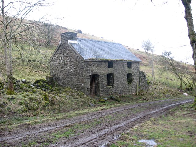
Anyone familiar with the uplands of Radnorshire and Montgomeryshire will have encountered the remains of a deserted farm. Sometimes little survives beyond a few walls, an overgrown yard or the outline of a building beneath the trees. Elsewhere, the farmhouse remains standing, although the land surrounding it has long since been incorporated into a neighbouring holding. There are places where even the buildings have disappeared, leaving only a name on an old Ordnance Survey map.
Many of these farms were occupied well into the twentieth century. They supported families, provided employment and formed part of communities whose existence depended upon the continued settlement of the countryside. Their disappearance was seldom recorded as an event of particular importance. A tenant retired or died, a family moved away, a neighbouring farmer acquired the land, and another house ceased to be occupied.
Taken individually, such changes might appear unremarkable. Collectively, they altered much of rural Mid Wales.
Between the later nineteenth century and the decades following the Second World War, Radnorshire and Montgomeryshire experienced a prolonged decline in their agricultural population. Small farms were amalgamated, younger generations sought employment elsewhere, and extensive areas of upland country were given over to commercial forestry. In some districts, reservoirs and other public works brought further changes to established patterns of settlement.
The consequences extended well beyond agriculture. The disappearance of farming households affected schools, chapels, village shops, local trades and the ordinary relationships upon which rural communities depended.
To understand what happened, we must look beyond the abandoned buildings themselves and consider the families who occupied them, the economic conditions under which they lived and the decisions which gradually transformed the countryside.
A More Populated Countryside
The countryside of nineteenth-century Mid Wales supported a pattern of settlement that was, in many upland districts, considerably more extensive than that familiar today.
Across the hills and valleys were farms of widely differing size and character, from substantial estates and prosperous tenanted holdings to modest properties supporting families through livestock farming, cultivation and occasional employment elsewhere.
The smaller holdings were seldom easy places in which to make a living. Their buildings could be basic, the land difficult to cultivate and the income uncertain. Much depended upon the labour of the household itself.
Men, women and children contributed to the agricultural economy. Livestock required constant attention, haymaking demanded considerable physical effort, and the maintenance of buildings, boundaries and drainage was a continuing responsibility. On a small farm, the distinction between domestic life and employment was often slight.
Tenure also shaped the circumstances of rural families. Some farmers owned their holdings, but many occupied land belonging to the larger estates. A tenant might remain on the same farm for decades, sometimes succeeding a parent or another relative, while ultimate ownership of the property remained elsewhere.
The relationship between landlord and tenant could be longstanding and mutually beneficial. It could also create considerable dependence, particularly where a family’s home and livelihood were tied to the same tenancy.
For those concerned, a farm represented more than an occupation. It was a home, a source of income and frequently the place with which several generations had been associated.
In Montgomeryshire, farms extended across the hills around Llanidloes, Llanwrin, Trefeglwys and the upper Clywedog Valley. Radnorshire possessed similar communities in the uplands surrounding Rhayader, the Elan Valley and the more isolated districts of the old county.
These holdings supported a network of institutions and relationships. Families attended chapels and churches, children walked to rural schools, farmers traded in local markets, and agricultural workers relied upon employment within the surrounding district. The countryside was never entirely self-sufficient, but its social and economic life depended heavily upon the continued presence of people.
The Movement Away from the Land
The decline of rural population was already evident during the nineteenth century. Industrial development created opportunities which the agricultural districts of Mid Wales could seldom provide. The coalfields of South Wales, the towns of the English Midlands and the expanding commercial centres of Britain attracted men and women seeking regular employment.
Others emigrated overseas, sometimes following relatives who had already established themselves in North America or elsewhere.
The reasons for leaving varied. A younger son might have little prospect of succeeding to the family farm. Agricultural labourers could improve their circumstances by moving to districts where wages were higher, while young women often found employment in domestic service or other occupations beyond their immediate communities.
It would be wrong to assume that everyone departed reluctantly. Rural life could be hard, and the attractions of regular wages, greater independence and improved living conditions were considerable. Later generations have sometimes been inclined to romanticise a way of life which offered those experiencing it few comforts and limited opportunities.
Nevertheless, the cumulative consequences were serious. The 1891 Census recorded a decline of 11.68 per cent in the rural population of Montgomeryshire during the preceding decade. In Radnorshire, the corresponding reduction was 7.58 per cent.
These were among the most substantial reductions recorded in the rural districts of England and Wales. Such figures represented the departure of working people, the ageing of communities and the gradual contraction of local economic life.
A farm did not necessarily become deserted when its younger members left. Some households continued with fewer people, while elderly farmers remained in occupation long after their children had established lives elsewhere. The difficulty came when there was nobody willing or able to succeed them.
Where a family had occupied a property for generations, the retirement or death of its last farmer could bring that association to an end. The land might continue to be worked, but a separate household was no longer required. In this way, the pattern of settlement gradually changed.
The Changing Agricultural Economy
Migration coincided with important changes in British agriculture. During the later nineteenth century, competition from imported produce placed pressure upon farmers. Improvements in transport and the increasing integration of agricultural markets affected the prices obtainable for livestock and crops.
In the uplands of Radnorshire and Montgomeryshire, livestock increasingly dominated an economy which had formerly included more extensive cultivation. Fields once used for growing crops were converted to permanent pasture, while some smaller holdings became part of larger agricultural units.
Upland cultivation could be labour-intensive and expensive. Where land was better suited to grazing, or where the costs of maintaining a separate holding could no longer be justified, amalgamation offered an alternative. A neighbouring farmer might acquire an adjoining property, using its fields and buildings without maintaining another household.
Such arrangements helped some agricultural businesses remain viable. They also reduced the number of families living on the land.
Their abandonment did not necessarily mean that the surrounding land had become worthless. Often the holding had simply ceased to exist as an independent agricultural and domestic unit.
The agricultural difficulties of the 1920s and 1930s placed further pressure upon smaller properties. Research undertaken by the Clwyd-Powys Archaeological Trust in the upper Clywedog Valley identified farms and cottages abandoned during this period, including Ty’n-y-fuches, Rhol-y-felin and Lluest-y-fedw.
The surviving evidence points to a gradual process of agricultural reorganisation. Some fields continued to be grazed, while other areas reverted to rough vegetation. Formerly cultivated land became pasture, and buildings were allowed to deteriorate once they were no longer needed.
Land-use surveys undertaken during the 1940s showed that some more remote areas and steeper hillsides, formerly used for grazing, had reverted to bracken and gorse. The landscape was changing long before the most extensive post-war forestry programmes reached their height.
The Forgotten Hardship of Mid Wales
By the middle of the twentieth century, rural depopulation had become a matter of national concern. The Mid-Wales Investigation Report, published in December 1955, examined agricultural conditions across approximately 300,000 acres of Cardiganshire, Montgomeryshire and Radnorshire.
Its findings provide an unusually revealing picture of the circumstances in which many farming families were still living. Of the 1,404 holdings investigated, 570 had no tractor and 838 possessed no form of motorised transport. Nearly 1,200 lacked electricity. Seven in ten had no piped water supply, and some households depended upon collecting rainwater in containers.
These conditions were being recorded in the 1950s, at a time when electricity, motor transport and modern domestic conveniences were becoming increasingly familiar elsewhere in Britain.
The report also exposed the ageing agricultural population. During a House of Commons debate on 4 July 1956, James Griffiths drew attention to the age of farmers in the investigation area.
Of the 1,404 farm occupiers, only twenty-one were under thirty. Approximately two-thirds were over fifty. In one valley containing nine farms, the occupiers were aged forty-five, forty-five, fifty, fifty-four, sixty-five, sixty-nine, seventy, eighty-one and eighty-three.
A farm might remain occupied and productive while its owner or tenant was physically capable of continuing, but there was no assurance that a younger generation would take over.
The report also recorded a substantial decline in employment across the three counties. Between 1901 and 1951, the number of people classified as gainfully employed fell from 34,773 to 23,235, a reduction of approximately one-third.
Not all those losses were directly attributable to farming. Mining, quarrying, rural crafts and other occupations had also declined. Nevertheless, the figures illustrate how difficult conditions had become.
For a young person growing up on an isolated holding without electricity, reliable transport or a piped water supply, the attractions of employment elsewhere are not difficult to understand. The disappearance of rural households was therefore not simply a consequence of agricultural prices or government policy. It was also connected with the ordinary desire for a better standard of living.
Forestry and the Transformation of the Uplands
Among the most visible changes to the countryside during the twentieth century was the expansion of commercial forestry. The Forestry Commission was established in 1919, following concerns about Britain’s dependence upon imported timber and the depletion of domestic supplies during the First World War.
The uplands of Wales offered considerable opportunities for planting. Land considered marginal for agriculture could be brought into timber production, providing employment and a long-term national resource.
In Montgomeryshire, the development of Hafren Forest brought extensive planting to hills previously associated with sheep farming. The Forestry Commission acquired twelve upland sheep farms in 1937, and planting commenced during the winter of 1937–38.
A contemporary Forestry Commission account, published in the international forestry journal Unasylva, explains that the twelve farms were initially retained as agricultural units, although with reduced acreages.
The acquisition of land for forestry did not necessarily mean the immediate abandonment of every farmhouse or the complete disappearance of agricultural activity. The principal change was the reorganisation of land use.
Extensive areas of former grazing became commercial woodland, while farming continued on the land retained for agricultural purposes. The developing forest also created a demand for workers.
Initially, local cottagers provided much of the labour, supplemented by men transported daily from Llanidloes. As the plantations developed and additional forestry work became necessary, the Commission sought a more permanent workforce.
The result was the creation of Llwyn-y-gog, near Staylittle. Designed by the Welsh architect T. Alwyn Lloyd, the proposed settlement was intended to contain eighty houses, a shop, school and village hall. Construction began in 1949, and by 1951 twenty houses had been completed.
The larger village never developed as originally envisaged. Nevertheless, the scheme provides an interesting example of the authorities attempting to establish a new rural community around a changing industry.
Where agricultural employment had once been distributed among numerous independent farms, forestry encouraged a more concentrated arrangement of housing and work. The policy brought benefits, but it did not reproduce the communities which had previously occupied the surrounding hills.
Nor did the expansion of forestry proceed without disagreement. During the parliamentary debate of July 1956, Goronwy Roberts, the Labour Member for Caernarvon, criticised the manner in which some land had been acquired for planting. He argued that forestry should develop in partnership with agriculture and expressed concern about farmers losing valuable grazing land.
The surviving evidence does not justify treating the Forestry Commission as solely responsible for rural depopulation. Much of the movement away from the land had begun decades earlier. Equally, the expansion of forestry permanently altered the character and agricultural prospects of substantial areas of Mid Wales.
Tymawr and a Montgomeryshire Family Connection
The disappearance and reorganisation of upland farms has particular significance within my own family history.
My grandfather, Griffith Llewellyn Davies, and his brother David Davies of Caeadda were associated with agricultural property in Montgomeryshire.
Among the holdings remembered within the family was Tymawr, which, according to family recollection, was lost following my grandfather’s death and subsequently became associated with forestry.
The precise circumstances of that transfer remain to be established from the surviving property records. Family memory does not necessarily preserve the legal or financial arrangements under which land changed hands.
Nevertheless, the recollection provides a personal connection with the wider transformation of the Montgomeryshire countryside.
A farm might be described in official records by its acreage, valuation, ownership and suitability for agricultural or forestry use. To the family associated with it, the same property might represent several generations of work, inheritance and domestic life.
My research into the Davies family of Caeadda, near Llanwrin, has repeatedly demonstrated the importance of such connections. Through census returns, parish registers, wills and other surviving records, it is possible to follow farming families across successive generations and identify relationships between neighbouring holdings.
Brothers might occupy adjoining farms. Children married into other agricultural families, while elderly parents and unmarried relatives sometimes remained within the household. Land, family and community were closely connected.
When a farm ceased to be occupied, these relationships did not necessarily disappear immediately. Descendants might continue living in the district, retain neighbouring property or preserve an attachment to the former holding.
Over time, however, the physical connection could weaken. Buildings deteriorated, boundaries changed and the original family associations became less widely remembered. The history of such properties deserves attention while sufficient evidence survives to reconstruct it.
The Effect Upon Rural Communities
The loss of small farms affected more than the people who occupied them. In rural Radnorshire and Montgomeryshire, farming households were linked to their communities through trade, employment, education and religious life.
Farmers purchased goods locally, employed craftsmen, attended markets and made use of services provided by nearby villages and towns. Children attended local schools, while adults played an important part in the life of parish churches, Nonconformist chapels and voluntary organisations.
The disappearance of one household might have little immediate consequence. The loss of several over a generation could considerably weaken a community.
Schools became more difficult to maintain where the number of children declined. Chapels experienced ageing congregations and found it increasingly difficult to replace members who died or moved away. Shops and other small businesses lost customers.
The effects were particularly noticeable in isolated districts where travelling distances were considerable.
Staylittle, near Llanidloes, provides an example of the broader changes affecting rural settlements. During the nineteenth century, the surrounding district supported a mixture of farming, mining and associated occupations.
The decline of mining, together with agricultural amalgamation and depopulation, contributed to the abandonment of farms, smaller cottages and chapels. Some buildings were subsequently renovated and found new uses.
The surviving settlement therefore illustrates both the decline of an older rural economy and the gradual adaptation of the countryside to different circumstances.
Such developments were not confined to Montgomeryshire. Similar changes occurred across Radnorshire, although the extent and chronology varied between districts.
The decline of a chapel or the closure of a school should not always be considered in isolation. Frequently, these events belonged to the same wider process by which the population and economy of the countryside were changing.
Reservoirs and the Loss of Settlement
The construction of reservoirs brought further changes to established patterns of occupation.
In Montgomeryshire, the creation of Clywedog Reservoir between 1964 and 1967 permanently altered a substantial part of the upper valley. The scheme was designed principally to regulate the River Severn, helping maintain adequate flows and water availability downstream during periods of low rainfall.
Archaeological research indicates that approximately nine or ten farms and cottages were lost through the flooding of the valley. Some of these properties had already been abandoned before the reservoir was constructed.
The flooding of a deserted building was not the same as requiring an occupied household to leave its home. Nevertheless, the reservoir removed physical evidence of earlier settlement and changed a landscape which had supported agricultural activity for centuries.
The Clywedog Valley had already experienced considerable changes in farming and land use before construction began. Archaeological investigations suggest that some settlements originated as seasonal upland dwellings, subsequently developing into more permanent agricultural holdings.
Elsewhere in Wales, reservoirs similarly transformed established landscapes, including Llanwddyn, the Elan Valley and, most controversially, Capel Celyn.
The circumstances of these schemes differed, as did the extent of public opposition and the consequences for individual communities. They nevertheless demonstrate how the requirements of urban and industrial society could bring substantial changes to rural districts.
The history of such developments should include both the purposes for which they were undertaken and the experiences of those whose properties and communities were affected.
The Older History Beneath the Landscape
Not every deserted farm in the Welsh uplands belongs to the agricultural decline of the nineteenth and twentieth centuries. Settlement across the region has changed repeatedly over a much longer period.
During the 1990s, the Clwyd-Powys Archaeological Trust undertook a programme of fieldwork examining deserted medieval and early post-medieval settlement sites in Radnorshire. By 1998, approximately 300 sites had been identified and recorded.
Many consisted of platforms cut into hillsides, sometimes associated with field systems and other evidence of cultivation.
These remains belong to a considerably earlier period than the modern disappearance of small farms. Some reflect changes associated with medieval agriculture and settlement. They should not be confused with farmhouses abandoned in the 1920s or 1930s.
Nevertheless, the archaeological evidence demonstrates that parts of the countryside now regarded as remote or largely unoccupied have supported different patterns of settlement over many centuries.
Old field boundaries, tracks, building platforms and abandoned enclosures can preserve evidence of land use which is not apparent from the modern landscape.
In some cases, the physical remains of a farm may be connected with named individuals recorded in census returns, tithe apportionments or estate papers. By examining these sources together, it becomes possible to recover something of the lives of people whose homes have otherwise disappeared.
Could the Decline Have Been Prevented?
The disappearance of small farms is sometimes explained as an unavoidable consequence of agricultural modernisation. Improvements in farming methods, changing employment patterns and the greater efficiency of larger holdings reduced the number of people required to work the land.
Many younger people preferred the opportunities available in towns, while some small farms could no longer provide a satisfactory income. The older pattern of settlement could hardly have remained entirely unchanged while the wider economy developed around it.
Yet the question of whether individual farms might have survived under different circumstances was being debated at the time.
The 1955 Mid-Wales Investigation Report considered the amalgamation of holdings as one means of improving agricultural efficiency. Its recommendations attracted criticism.
During the parliamentary debate of July 1956, Goronwy Roberts challenged the assumption that larger farms were necessarily the answer in every case. He argued that small holdings could provide opportunities for younger farmers without substantial capital and warned against compulsory amalgamation.
Larger agricultural units might operate more efficiently while requiring fewer workers. The preservation of small farms might maintain rural households, but without improvements in income, housing and essential services, younger people would continue to leave.
Government policy attempted to address these difficulties through agricultural improvement, forestry and later regional development. The expansion of Newtown as a development centre represented one response to the continuing economic problems of Mid Wales.
Such policies helped create new opportunities, but they did not restore the older pattern of upland settlement. Nor would everyone who had left necessarily have wished to return to it.
There was a difference between maintaining the population of a region and preserving the communities in which that population had traditionally lived. The two objectives were not always compatible.
Recovering the History of the Lost Farms
Much of the history of these abandoned holdings remains recoverable.
The Welsh tithe maps of the nineteenth century, together with their accompanying apportionments, provide a particularly useful starting point. They identify landowners, occupiers, field boundaries and the use of individual parcels of land.
Census returns allow households to be reconstructed, often revealing changes in family circumstances and the movement of children between districts. Parish registers, chapel records, wills and estate papers may extend the history considerably further.
Historic Ordnance Survey maps show how buildings, boundaries and access routes altered over successive generations. Newspaper reports sometimes preserve details of property sales, agricultural disputes, accidents and other events involving individual farms. The archaeological record provides an additional source of evidence where buildings or field systems survive.
A farmhouse identified on a nineteenth-century map becomes considerably more meaningful when its occupiers can be traced through successive censuses, connected to neighbouring families and followed through later property transactions. It may then be possible to establish when the holding ceased to be occupied and what subsequently happened to its land.
Care is required when interpreting such evidence. Not every abandoned farm represents a family forced from its home. Some holdings ceased to exist through retirement, inheritance, economic choice or ordinary agricultural reorganisation.
Others changed ownership as part of forestry schemes or public works, sometimes under circumstances requiring closer investigation. Family recollections can preserve valuable information, but should be considered alongside the documentary record wherever possible.
The purpose of historical research is to establish what happened to individual properties and the people associated with them, rather than assume that every abandoned farm has the same history.
The Disappearance of a Rural Society
The transformation of Radnorshire and Montgomeryshire between 1880 and 1970 was neither sudden nor uniform.
Some districts experienced substantial depopulation, while others retained a comparatively stable agricultural population. Certain farms prospered through expansion, and new opportunities emerged in forestry, public works and the developing towns.
It would be wrong to regard the countryside as having declined from an earlier period of uninterrupted prosperity. Many nineteenth-century farming families lived under difficult circumstances, and the movement towards better-paid employment brought advantages which should not be overlooked.
Nevertheless, the disappearance of so many small farms altered the social character of the Welsh uplands.
A countryside once occupied by numerous farming households came increasingly to be managed through larger agricultural units, forestry estates and other forms of land use. Economic activity did not necessarily disappear, but the number of people living and working directly upon the land was greatly reduced.
For individual families, the consequences could extend across generations. A holding which had provided a home and livelihood became part of a neighbouring farm, a commercial forest or the site of a reservoir. Its former occupants moved elsewhere, and their descendants gradually lost direct contact with the property.
In some cases, only the name survived.
The history of these farms deserves more attention than it has sometimes received. It is not simply a matter of agricultural economics, forestry policy or the changing appearance of the countryside.
It concerns families whose lives were closely connected with particular places, and communities whose existence depended upon their continued occupation.
Across Radnorshire and Montgomeryshire, the remains of deserted holdings provide evidence of a rural society which was still recognisable little more than a century ago. Their histories can be reconstructed, but the opportunity should not be neglected.
As buildings deteriorate and the generations possessing first-hand knowledge of them disappear, valuable evidence is lost.
The task for local historians is to establish who occupied these farms, how they lived and why their connection with the land eventually came to an end.
In doing so, we recover more than the history of abandoned buildings. We recover part of the social history of Mid Wales, and the families whose work and lives helped shape its countryside.
Related Essays
- Caeadda, Llanwrin: Three Centuries of Farming in the Montgomeryshire Uplands
- Esgair Llewelyn: A Medieval Welsh Farmhouse and the Social History of a Llanwrin Family
- The Ceniarth Farm Dispute of 1900: A Montgomeryshire Farmer Challenges His Landlord
- A Valley Remade: The Lost Families, Navvies and Changing Language of Elan
- The Monks’ Trod: A Medieval Road Through the Cambrian Mountains
- When an English City Drowned a Welsh Village: Llanwddyn and the Making of Lake Vyrnwy
Explore More Welsh Rural History
Continue with the Welsh Rural History, Radnorshire History, Montgomeryshire History and Family History & Genealogy guides. The family history publications The Davies Caeadda Family and Voices from the Uplands provide further context.
Sources and Further Reading
General Register Office, Census of England and Wales, 1891: General Report, sections on rural population decline, including Radnorshire and Montgomeryshire. A Vision of Britain Through Time.
Welsh Agricultural Land Sub-Commission, Mid-Wales Investigation Report, Cmd. 9631, HMSO, December 1955.
House of Commons, Agricultural Land (Mid-Wales Investigation Report), 4 July 1956, Hansard, vol. 555, columns 1333–1394, including agricultural conditions, rural depopulation and forestry. Historic Hansard.
H. L. Edlin, “Britain’s New Forest Villages”, Unasylva, vol. 6, no. 4 (1952), on Hafren Forest, its agricultural holdings and Llwyn-y-gog. Food and Agriculture Organization.
Clwyd-Powys Archaeological Trust, Clywedog Valley Historic Landscape Characterisation: Settlement and Land Use, concerning deserted farms, agricultural change and Clywedog Reservoir. Historic landscape survey.
Clwyd-Powys Archaeological Trust, Clywedog Valley: Hafren Forest, Historic Landscape Character Area 1189. Historic landscape record.
Clwyd-Powys Archaeological Trust, Staylittle and Llwyn-y-gog, Historic Landscape Character Area 1188. Historic landscape record.
Clwyd-Powys Archaeological Trust, Deserted Rural Settlements, Radnorshire, assessment project (1998), Historic Environment Record PRN 72025. Historic Environment Record.
National Library of Wales, Welsh Tithe Maps, nineteenth-century maps and apportionments; historic Ordnance Survey mapping of Radnorshire and Montgomeryshire.
Davies family records and recollections concerning Griffith Llewellyn Davies, David Davies of Caeadda, Llanwrin and Tymawr. The precise circumstances of the transfer of Tymawr require further documentary investigation.
Featured photograph: Abandoned farmhouse near Llanbadarn Fynydd, Radnorshire, photographed by Colin Bell on 29 March 2010. Reproduced from Wikimedia Commons under the Creative Commons Attribution-ShareAlike 2.0 licence. The original photograph has not been altered.
